Wetlands are important for sustaining the health and resilience of the Great Barrier Reef and provide many benefits to society and the environment. Historical loss of wetland extent has been significant for some wetland types in some regions. Natural and near-natural wetlands, and healthy rivers have the potential to support water quality improvement. Wetlands can be restored to enhance water quality benefits while still maintaining wetland values, health and function.
Why are wetlands of the Great Barrier Reef important?
Wetlands (riverine, estuarine, palustrine or vegetated swamps and lacustrine) cover 4% approximately of the Great Barrier Reef catchment area. Wetlands are recognised for their multiple ecological, social, economic, and cultural (including Indigenous and non-Indigenous) values.

Cultural

Biodiversity and habitat

Nursery habitat

Maintain or improve water quality

Coastal and flood protection

Carbon storage

Water resource

Aesthetics and recreation
How much of the Great Barrier Reef catchment is wetlands and where are wetlands located?
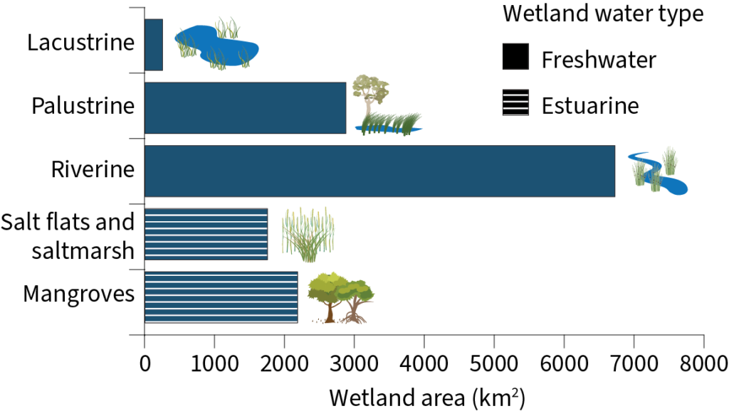
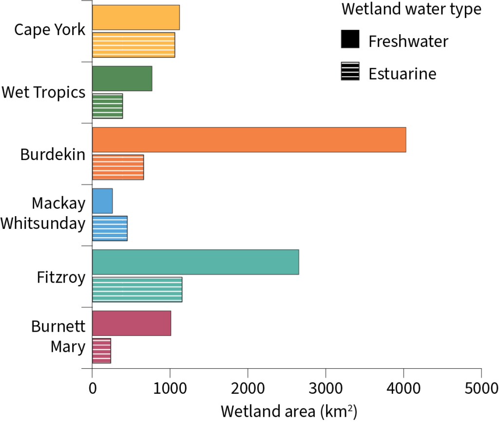
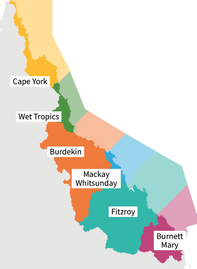
Wetlands cover 15,556km2 of the GBR catchment (~85% of pre-development extent), including riverine wetlands (43%), estuarine (mangroves, salt flats and saltmarshes; 25%), palustrine (vegetated swamps; 18%) and lacustrine (lakes; 1.6%). Regionally, the Burdekin contains the greatest area of wetlands (34%), followed by Fitzroy (29%), Cape York (14%), Burnett Mary (10%), Wet Tropics (8%), and Mackay Whitsunday with the least (5%).
What’s the condition of wetlands in the Great Barrier Reef catchment area?
Historical loss of some wetland types has been substantial (especially for palustrine wetlands such as vegetated swamps in most regions), but trends in extent have stabilised. Currently, natural wetlands (lakes, swamps and estuaries) in the Great Barrier Reef catchments have low rates of area loss. Mangroves and saltmarsh ecosystems are considered stable and in Good condition[1], while freshwater wetlands are considered stable but in Moderate condition[2].
[1] Great Barrier Reef Outlook Report 2019
[2] Reef Water Quality Report Card 2020
Some of the key wetland types in the Great Barrier Reef catchment area
Wetland area by Natural Resource Management region
Threats to wetlands
Vegetation clearing
Landscape modification
Changes in hydrological connectivity due to agricultural and urban development
Poor water quality
Invasive species
Climate change including increasing temperature, flooding, storms and sea level rise
New wetlands can be constructed to improve water quality and provide other values if carefully designed
Sediments, nutrients, pesticides, and other pollutants can be introduced to wetlands through surface runoff and ground water
The effectiveness of constructed wetlands in pollutant removal, if properly designed and maintained, can improve over time as the processes they support mature
Water quality impacts
Sediments can reduce light, reduce available habitat, modify species composition and behaviour, and smother mangrove seedlings and roots
Nutrients can cause excessive growth of algae and weeds, changes in community composition, and lead to fish kills due to low oxygen levels
Pesticides can affect the whole food chain by reducing plant growth, modifying community composition, causing harm to invertebrates and fish
The effects of poor water quality, in particular, sediments and nutrients, are understudied in the freshwater and estuarine wetlands of the Great Barrier Reef