Sugarcane is the second largest agricultural export in Queensland and covers 400,000 ha in the Great Barrier Reef catchment. Sugarcane growing contributes 42% of the total dissolved inorganic nitrogen load and is the dominant source of pesticides delivered to the Great Barrier Reef. Several land management practices in sugarcane areas are proven to be cost-effective in improving water quality, but translating these into more substantial pollutant reductions requires scaling up and greater knowledge of the costs and co-benefits of practice adoption.
Water quality and the Great Barrier Reef
Poor water quality, which can be caused by elevated levels of fine sediments, nutrients and pesticides, has a detrimental impact on Great Barrier Reef ecosystems, particularly freshwater, estuarine, coastal and inshore marine ecosystems. These environments provide critical ecosystem services and have high tourism, aesthetic, cultural, recreational and economic values.
How do land-based activities affect water quality?
The Great Barrier Reef catchment area has been modified by changes in land use over time. These modifications affect the type and amount of materials that runoff from land and enter our waterways.
Compared to pre-development conditions, the volume of river discharge and loads of suspended sediment, dissolved and particulate nutrients (nitrogen and phosphorus), and pesticides have increased for most river basins of the Great Barrier Reef catchment. Overall, exports of anthropogenic dissolved inorganic nitrogen are twice as high as pre-development rates, mainly as a result of fertiliser applied to crops and pastures.
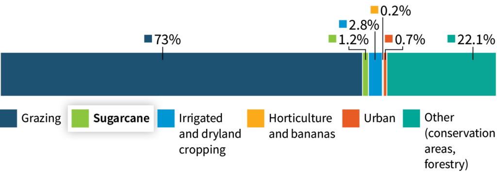
Land uses in the Great Barrier Reef catchments
How do sugarcane growing areas contribute to overall pollutant loads?
Basins dominated by sugarcane make the greatest contribution to total dissolved inorganic nitrogen exports (42% of total) through the use of nitrogen-based fertilisers. Other land uses including urban, bananas and other horticulture contribute smaller amounts but can be locally important. Sugarcane areas are the largest contributor to end-of-catchment pesticide concentrations (>97% in some regions) and are dominated by photosystem II herbicides. Sugarcane areas also contribute 10% of fine sediment and particulate nutrient exports to the Great Barrier Reef although grazing lands are the major contributor (~60%).
Dissolved inorganic nitrogen loads by land use

How are changes to land-based runoff measured
Scientists use multiple lines of evidence to estimate changes over time

Monitoring

Modelling

Remote sensing

Records of fertiliser use

Geochemical and isotope tracing
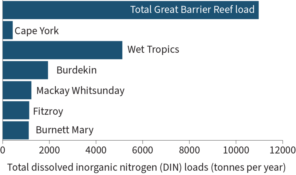
Which areas are the dominant sources of key pollutants associated with sugarcane?
Anthropogenic exports of dissolved inorganic nitrogen are greatest in basins dominated by sugarcane including those in the Wet Tropics, Burdekin and Mackay Whitsunday Natural Resource Management (NRM) regions.
Total dissolved inorganic nitrogen loads by NRM region
Sites in the Mackay Whitsunday region, along with Barratta Creek in the Burdekin region, that feature intense cropping and lower river and creek flows (related to rainfall), consistently record higher concentrations of pesticides and higher ecological risk than other locations.
Drivers and transport pathways
Most export occurs in the wet season, with chronic and continuously high exports of dissolved nutrients in wet tropical catchments
Primary drivers of anthropogenic nitrogen and phosphorus export:

Fertiliser application

Changed catchment hydrology

Erosion
Primary drivers of fine sediment and particulate nutrient export:

Vegetation loss

Tillage
Drivers influencing pesticide export:

Timing and rate of application

Irrigation regimes

Pesticide and soil properties
Significant transport pathways
Surface runoff – dissolved nutrients and pesticides
Subsurface movement – dissolved nutrients
Groundwater – dissolved nutrients
Management options
To reduce dissolved nutrient exports:
Other things to consider

Enhanced Efficiency Fertiliser

Mill mud application

Improving irrigation efficiency

Improving farming systems (such as growing legumes in between sugarcane crops)

Sub-surface fertiliser application
To reduce sediment and particulate nutrient losses

Green cane trash blanketing

Zero tillage

Controlled traffic farming

Gradual elimination of water furrows by levelling

Repairing and/or revegetating eroding banks
To reduce pesticide risk

Reducing the total amount of pesticide applied

Optimising application methods

Timing application to coincide with low rainfall runoff

Choosing pesticides with lower environmental risk
Reducing soil erosion
Improving irrigation efficiency
Potential ecosystem impacts
Nutrients are highest in estuaries and inshore waters, and lower in midshelf and offshore waters
Sediments can reduce water clarity and light, decrease abundance diversity, spatial extent growth and recovery rates of seagrasses and coral reefs and associated communities
Excess nutrients can
have a negative impact, particularly on inshore coral reefs
be detrimental to coral health and increase coral
susceptibility to bleaching
cause phytoplankton blooms that can increase food supply for crown-of-thorns starfish larvae, possibly contributing to outbreaks
Climate change may exacerbate these effects further
Pesticides are present in most monitored fresh, estuarine and marine waters of the GBR
Pesticides are harmful to aquatic species and can increase species vulnerability to other stressors, including heatwaves and reduced light
The Mackay Whitsunday region and Barratta Creek in the Burdekin region, consistently record higher pesticide concentrations and risk than elsewhere